


Sverige Topo Kartan

Περιγραφή του Sverige Topo Kartan
Μια εφαρμογή πλοήγησης GPS για εσωτερική / εξωτερική χρήση που είναι εύκολη στη χρήση με πρόσβαση στους καλύτερους τοπογραφικούς χάρτες και δορυφορικές εικόνες για τη Σουηδία.
Απαιτούνται λειτουργίες PRO + για χρήση εκτός σύνδεσης! ++
Μεταμορφώστε το smartphone / tablet Android σε εξωτερικό GPS για ταξίδια σε αραιοκατοικημένες περιοχές ΧΩΡΙΣ ΚΑΛΥΨΗ ΚΥΤΤΑΡΟΥ. Αυτή η εφαρμογή σάς παρέχει παρόμοιες επιλογές χαρτογράφησης που έχετε συνηθίσει με τα ακουστικά GPS από Garmin ή Magellan.
Περιλαμβάνει ΔΩΡΕΑΝ αποθήκευση χαρτών:
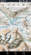
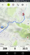
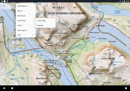
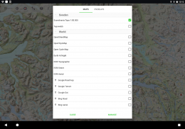
• Τοπογραφικός χάρτης 1: 50.000 για τη Σκανδιναβία (Δανία, Νορβηγία, Σουηδία και Φινλανδία) με σκίαση στο βουνό. Χάρτης εδάφους Lantmateriet + Χάρτης βουνών
• Topowebb: Lantmateriet Τοπογραφικός χάρτης της Σουηδίας
• OpenStreetMaps: Αυτοί οι χάρτες με πολλούς πόρους είναι μια πολύ χρήσιμη προσθήκη σε άλλα επίπεδα χαρτών και περιέχουν πολλές μοναδικές δυνατότητες
• OpenCycleMaps: Αυτοί οι χάρτες είναι ιδανικοί για το σχεδιασμό ποδηλάτων (μόνο για χρήστες PRO)
• Τοπογραφία ESRI
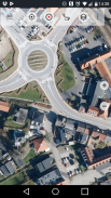
• Εναέριες φωτογραφίες ESRI
• Οδικός χάρτης ESRI
• Χάρτης πορείας Google (μόνο πρόσβαση στο διαδίκτυο)
• Δορυφορικές εικόνες Google (Μόνο διαδικτυακή πρόσβαση)
• Χάρτης Google Terrain (μόνο πρόσβαση στο διαδίκτυο)
• Χάρτης πορείας Bing (μόνο πρόσβαση στο διαδίκτυο)
• Δορυφορικές εικόνες Bing (Μόνο διαδικτυακή πρόσβαση)
• Γη τη νύχτα
• Επικάλυψη σκίασης βράχου
Κύριες λειτουργίες για πλοήγηση σε εξωτερικούς χώρους:
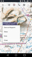
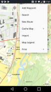
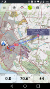
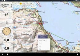
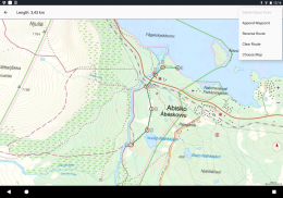
• Δημιουργία και επεξεργασία σημείων
• Μεταβείτε στην πλοήγηση σημείων
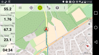
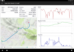
• Εγγραφή κομματιού (με ταχύτητα, υψόμετρο και προφίλ ακρίβειας)
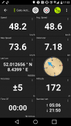
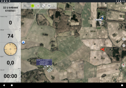
• Tripmaster με πεδία για μετρητές απόστασης, μέση ταχύτητα, ρουλεμάν, ύψος κ.λπ.)
• Εξαγωγή GPX / KML / KMZ
• Αναζήτηση (ονόματα θέσεων, POI, δρόμοι)
• Προσαρμόσιμα πεδία δεδομένων στο Map View και Tripmaster (π.χ. ταχύτητα, απόσταση, πυξίδα ...)
• Μοιραστείτε σημεία, ίχνη ή διαδρομές (μέσω email, Whatsapp, Dropbox, Facebook ...)
• Προβολή συντεταγμένων σε Lat / Lon, UTM ή MGRS / USNG (Στρατιωτικό δίκτυο αναφοράς / Εθνικό δίκτυο ΗΠΑ)
• Εγγραφή και κοινή χρήση κομματιών με στατιστικά και προφίλ ανύψωσης
• Περιστροφή χάρτη (κομμάτι και κομμάτι)
• Λάβετε υψόμετρο και απόσταση κάνοντας μακρύ κλικ στον χάρτη
• Παρακολούθηση αναπαραγωγής
• Προσθέστε προσαρμοσμένους διακομιστές χαρτών
• Και πολλα ΑΚΟΜΑ ...
Διαθέσιμο για PRO: (Διαθέσιμα χαρακτηριστικά Pro για αγορές εντός εφαρμογής)
• Χρήση εκτός σύνδεσης - δεν απαιτείται κάλυψη από κινητά. Χωρίς χρεώσεις περιαγωγής!
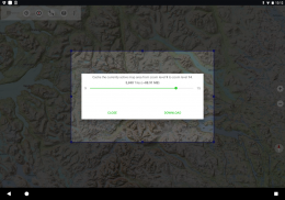
• Εύκολη και γρήγορη μαζική λήψη χαρτών για ΧΡΗΣΗ εκτός σύνδεσης (δεν ισχύει για χάρτες Google και Bing)
• Δημιουργία και επεξεργασία διαδρομών
• Πλοήγηση διαδρομής (πλοήγηση από σημείο σε σημείο)
• Εισαγωγή / εξαγωγή GPX / KML / KMZ
• Απεριόριστα με σημεία και ίχνη
• Προσθέστε άλλους διακομιστές χαρτών
• Χωρίς διαφημίσεις
Χρήση εκτός σύνδεσης:
Όλα τα πλαίσια χάρτη που εμφανίζονται διατηρούνται στην κρυφή μνήμη. Για την προσωρινή αποθήκευση μεγάλων περιοχών, πρέπει να αγοράσετε λειτουργίες Pro.
Χρησιμοποιήστε αυτήν την εφαρμογή πλοήγησης για υπαίθριες δραστηριότητες όπως πεζοπορία, ποδηλασία, κάμπινγκ, αναρρίχηση, ιππασία, σκι, καγιάκ, κυνήγι, εκδρομές εκτός δρόμου 4WD ή διάσωση στη θάλασσα (SAR).
Προσθέστε προσαρμοσμένα σημεία σε μήκος / γεωγραφικό πλάτος, UTM ή MGRS / USNG μορφή με ημερομηνίες WGS84.
Εισαγωγή / εξαγωγή / κοινή χρήση σημείων / κομματιών / διαδρομών GPS σε GPX ή σε μορφή Google Earth KML / KMZ.
Προφορτώστε ΔΩΡΕΑΝ δεδομένα χάρτη για περιοχές που δεν έχουν κάλυψη από κινητά (λειτουργία Pro).
Τα σχόλια και τα αιτήματα αποστέλλονται στη διεύθυνση swedenmaps@atlogis.com
Ρίξτε μια ματιά στις άλλες εξωτερικές εφαρμογές πλοήγησης:
https://play.google.com/store/search?q=atlogis
++ Δεν παρακολουθούμε τη δραστηριότητα των χρηστών και δεν συλλέγουμε δεδομένα χρήστη! ++
Sverige Topo Kartan - Έκδοση 7.8.0
(16-04-2025)
Sverige Topo Kartan - Πληροφορίες APK
Έκδοση APK: 7.8.0Πακέτο: com.atlogis.swedenΤελευταία έκδοση του Sverige Topo Kartan
Άλλες εκδόσεις


Εφαρμογές στην ίδια κατηγορία

Μπορεί επίσης να σου αρέσουν...


